Mapping Net Change in Carbon from Afforestation in Scotland
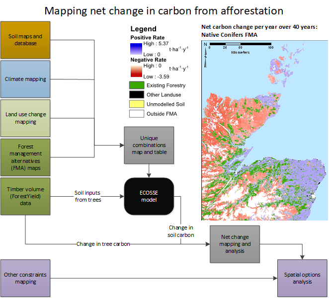
To help us better understand the carbon storage outcomes of woodland expansion in Scotland, the James Hutton Institute has created this online mapping tool to visualise net change in carbon (combining soils and vegetation) from afforestation over time for different woodland planting options. The map was developed with Mike Perks at Forest Research and Pete Smith at Aberdeen University and accompanies a paper published in Land Use Policy (Matthews et al., 2020).
See the graphical abstract .
This is the abstract of the paper:
Area-based targets for afforestation are a frequent and prominent component of policy discourses on forestry, land use and climate change emissions abatement. Such targets imply an expected contribution
of afforestation to the net reduction of greenhouse gas emissions, yet the nature of afforestation undertaken and its geographical distribution means that there is considerable uncertainty over the eventual emission reductions
outcomes. This uncertainty is reduced if the net carbon balance is calculated for all potential afforestation sites, considering climate, soil characteristics and the possible types of afforestation (species and management regimes).
To quantify the range of possible emissions outcomes for area-based afforestation targets, a new spatial analysis method was implemented. This improved the integration of spatial data on antecedent land use with mapped outputs
from forest models defining the suitability and productivity of eleven forestry management alternatives.
This above ground carbon data is then integrated with outputs from the ECOSSE (Estimation of Carbon in Organic Soils – Sequestration and Emissions) model which simulates the soil carbon dynamics. The maps and other output visualisations combining above and below ground carbon highlight where net carbon surpluses and deficits are likely to occur, how long they persist after afforestation and their relationships with antecedent land use, soils, weather conditions and afforestation management strategies. Using more productive land classes delivers more net sequestration per hectare and could mean greater carbon storage than anticipated by emissions reduction plans. Extensive establishment of lower yielding trees on low-quality ground, with organo-mineral soils could, though, result in net emissions that persist for decades. From the spatial analysis, the range of possible outcomes for any target area of planting is substantial, meaning that outcomes are highly sensitive to policy and implementation decisions on the mix of forestry systems preferred and to spatial targeting or exclusions (both at regional and local scales).
The paper highlights the importance of retaining the existing presumption against planting of deep peat areas, but also that additional incentives or constraints may be needed to achieve the aggregate rates of emission mitigation implied by policy commitments. Supplementary carbon storage tonnage targets for new forestry would introduce a floor for carbon sequestration outcomes but would still allow for flexibility in achieving an appropriate balance in the trade-offs between carbon sequestration and the many other objectives that new woodlands are expected to deliver.
Citation: Matthews, K.B., Wardell-Johnson, D., Miller, D.G., Fitton, N., Jones, E., Bathgate, S., Randle, T., Matthews, R., Smith, P., Perks, M., 2020. Not seeing the carbon for the trees? Why area-based targets for establishing new woodlands can limit or underplay their climate change mitigation benefits. Land Use Policy.

